Chapter 2 – Hydrology
Book Extract……………………………..
Groundwater and Aquifers
The presence and flow of groundwater is the key element to my hypothesis, so it is worth spending a bit of time in understanding what this substance is and how it flows invisibly under our environment.
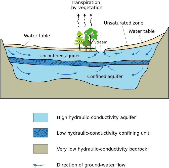
When a hole is dug in permeable rocks, at a particular depth water begins to flow inside. The surface level of the water in the void that accumulates is known as the water table, and the water below in the ground is known as groundwater. The variations in the shape of the water table reflect the topography in a subdued form. The water table is near the ground in valleys, actually intersecting the ground surface where rivers, lakes and marshes occur, but it is at much greater depths below hills, mimicking it’s contours.
The pore spaces of rocks are saturated with water below the water table, and groundwater is said to occur in the saturated zone. Immediately above the water table, water is drawn up into pore spaces by capillary forces into a thin area called the capillary fringe. Rocks above the water table, including the capillary fringe, form the unsaturated zone; although they do contain water, they are generally not completely saturated, and the water cannot be extracted.
Water is continually moving through the environment – we call this the water cycle. Water evaporates from the oceans, condenses into clouds and then falls on the land surface as rain, only to flow into rivers and back into the sea. However, there is one aspect of the water cycle that is often forgotten – groundwater. Rainfall doesn’t only reach rivers by running off over the land surface. Most of the rainfall will soak into the soil, which acts like a giant sponge.
In the earth some of the water will be taken up by plants and, through a process called transpiration, will return to the atmosphere, but some will soak further into the ground – a process called infiltration – and trickle downwards into the rocks, becoming groundwater. The level at which the rock becomes saturated is called the ‘groundwater table’. Water in this saturated zone will flow from where it has infiltrated to the point of discharge. This might be a spring, a river or the sea. Much of the flow of a river will be made up of discharging groundwater, and groundwater provides a vital role in supporting wetlands and stream flows.
Water is present almost everywhere underground, but some geological formations are impermeable – meaning that water can hardly flow through them – and some are permeable – they contain fine holes that allow water to flow. Permeable formations that contain groundwater are known as aquifers. The holes that water flows through can be spaces between individual grains in a rock like sandstone, or they can be networks of fine cracks. Very occasionally groundwater will flow in underground rivers, but this is the exception rather than the rule.
Today, groundwater comes from rain. The average annual rainfall over the UK is about 1100mm, ranging from more than 2500mm over highland Britain, to less than 600 mm on the lowlands of eastern England. A significant part, almost 500mm in lowland areas, evaporates, mainly in the summer. The remainder is available to infiltrate permeable rocks although where the rocks have low permeability or, where layers of relatively impermeable clay overlie them, part will flow over the ground as surface runoff. Water infiltrates the soil mainly in the winter and slowly moves down through the unsaturated zone, eventually reaching the water table and becoming groundwater.
| Figure 5 – How Aquifers work |
After temporary storage in the ground, groundwater drains from springs and seepages into streams and rivers. Maximum discharges occur at the end of the winter when groundwater levels are high following the seasonal infiltration. They then steadily decline throughout the summer into the autumn. The contribution that groundwater makes to the flow of rivers is called ‘base flow’, and it is responsible for maintaining the flow of rivers during extended periods of dry weather when surface runoff virtually ceases.
Groundwater provides about one-third of public water supplies in England and Wales, 7% in Northern Ireland and 3% in Scotland. The regional differences reflect the distribution of aquifers and the more favourable conditions for the development of surface water resources in both Northern Ireland and Scotland.
Groundwater makes up nearly 70% of all the worlds freshwater; only 0.2% is found in lakes, streams or rivers and 30% is bound up in snow and ice on mountains and in the Polar Regions. As rivers and lakes tend to be supported by groundwater, it is not exaggerating to say that almost all the water we use for agriculture, industry and drinking water is either groundwater or has been groundwater at some point in the water cycle.
Our major aquifers are contained in Chalk, Jurassic Limestones and Permo-Triassic sandstones, with substantial supplies available from other formations, such as river gravels and Carboniferous Limestone. Over recent years groundwater has been bottled for sale as mineral waters. Often these waters come from minor aquifers in upland areas where distinctive geology imparts interesting flavours.
It should be remembered that not all groundwater resides at sea level. The natural motion of water means that it moves from rainfall and springs down to rivers and eventually to the sea. However, the pace of this flow back to the sea is dependent on soil types and conditions. This is why we have lakes and reservoirs at high altitudes as they are situated on a form of impervious soil that does not readily leak water, and they are fed continuously by small streams which varies throughout Britain.
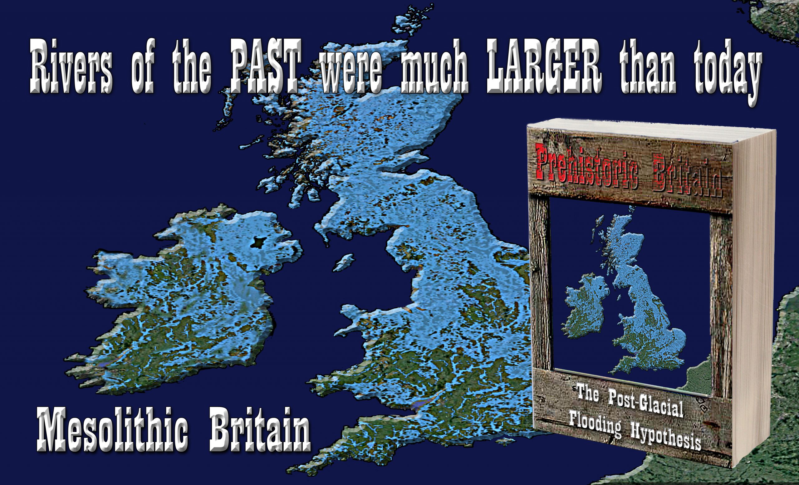
This vast mass of ice-sheet that covered Britain at the end of the last ice age also known as the Last Glacial Maximum (LGM) raised the groundwater tables and left the land saturated. The volume of water was so high (8.42 quadrillion tonnes) that it eventually made a significant contribution to sea level rises that created the English Channel, Irish Sea and eventually the North Sea.
But how much water was absorbed into the ground and how can we prove that it eventually turned into rivers that filled the seas and channels around Britain?
The Journal of Geophysical Research (Lemieux et al., 2008) showed that the Pleistocene glaciations had a significant impact on North American regional groundwater flow systems – Regional groundwater flow systems generally involve a large area (10 – 100 km2). Usually, they contain several local flow systems, resulting in areas of local recharge as well as springs or other discharge features within the more extensive system. Often several different aquifers and geologic formations will be connected by a more comprehensive regional groundwater system.
“Recently, several studies, using environmental isotopes and salinity data, have suggested that sufficient subglacial meltwater may have infiltrated into the subsurface under ambient ice sheet pressure and therefore become stored in the groundwater” according to Lemieux.
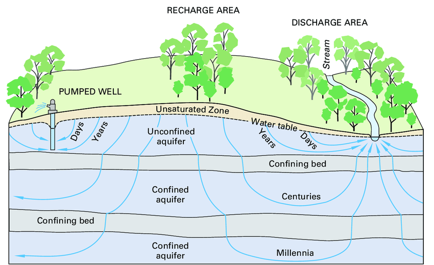
| Figure 5 – Location of Aquifers and recharge time depending on depth |
The paper goes on to look at the effect of not only the glacier that covered the Eurasia continent but moreover, the effects of permafrost that spread hundreds of kilometres from the edge of the ice caps and other factors.
“We include other important factors, such as the influence of permafrost developing/thawing, changing the topography due to isostasy, sea-level change on the coastal margins due to ice sheet formation/thawing and the presence of high-salinity paleobrines at depth in the continental interior”.
The Maths
In a later paper, Lemieux (2017) had constructed a model to calculate the amount of ice is absorbed into the ground to become groundwater.
“Glaciations are known to have a large and long-lasting impact on groundwater flow. Several geochemical and isotopic studies have shown that water of glacial origin is still present in basins in North America and northern Europe that were formerly covered by ice-sheets. The presence of glacial water is commonly identified by low salinity, depletion in heavy isotopes such as 18O and 2H, high excess air, cold recharge temperature inferred from noble gases, and old groundwater age”.
Moreover, what the research article also provides is the evidence that the meltwater will recharge the groundwater under the landmass as it recharges it throughout the glaciers life-cycle and not just the end during the glaciers retreat.
“Subglacial recharge of meltwater is the prevailing hypothesis of recharge of water of glacial origin during the Pleistocene. Ice-sheets can be partially wet-based due to basal friction and can release large volumes of subglacial meltwater. If the permeability of the ground is sufficient, it was put forward that meltwater could infiltrate into the subsurface under pressure exerted by the ice sheet showed that recharge of supraglacial meltwater could also occur below ice-sheets due to the presence of crevasses”.(Lemieux,2017)
The paper also concluded that “By the end of the glacial maximum (15 ky B.P.), the meltwater contents in the intermediate and lower aquifers are about 10 and 12.5%, respectively and in the same aquifers, meltwater has travelled about 50 and 75 km”.
Therefore, even BEFORE the ice cap retreated and completely melted, meltwaters had moved tens of kilometres into the surface and had partly recharged the aquifers.
The conclusion by Lemieux indicates that “The average infiltration/exfiltration fluxes range between 1 and 12 mm/a. Using mixed, ice sheet thickness-dependent boundary conditions for the subglacial environment, it was estimated that 15–70% of the meltwater infiltrated into the subsurface as recharge, with an average of 43%.”
Therefore, we can now return to our original meltwater calculation of 8.42 quadrillion tonnes of water for the Fennoscandia & U.K. Ice Sheet to give us an estimate of groundwater in the land at the end of the last ice age.
According to ‘Table 1’ The Fennoscandian and Great Britain ice sheet covered 9.18 106 KM2, which is equivalent to:
- 8.42 106 Gigatonnes of water / 9.18 106 km2, which gives us 0.92 Gt per km2
- 0.92 Gt of water at a penetration rate of 43%, give us 0.4 Gt of water per km2
- 0.4 Gigatonnes of water by U.K. landmass 242,495 km² give us 96,998 Gt of groundwater in the ground even BEFORE the start of the Meltwater pulses
Moreover, this water will be released at a rate of 1 – 12mm per annum and be at a depth of possibly 75km. Therefore, to release groundwater at a depth of 75km at an average rate of 6mm per annum would take 12,500 years – not the 1,200 years previously believed, which is just the surface meltwater from the latter stages of last ice age.
Precipitation
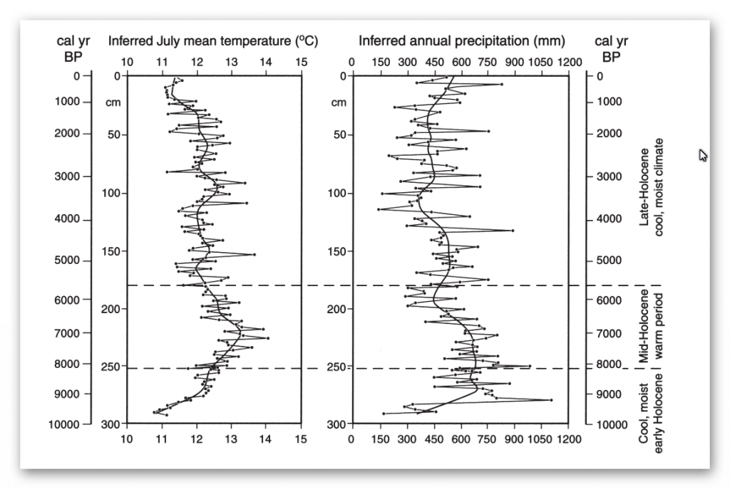
July mean temperature and annual precipitation during the last 9900 cal. Yr B.P. were reconstructed from pollen assemblages preserved in a sediment core from northern Finland. Quantitative reconstructions were performed using a modern pollen-climate calibration model based on weighted-averaging partial least squares regression.
The predictive ability of the model was evaluated against modern meteorological data using leave-one-out cross-validation. The July mean temperatures during the earliest Holocene were low, c. 11.0°C and annual precipitation were high, c. 600–800 mm. Between 8200 and 6700 cal. Yr B.P. July mean temperatures reached their maxima, 12.5–13.0°C, which is c. 1.4–1.7°C higher than at present (Seppa et al. 2001)
The graph indicates that the climate rainfall after the last ice age change drastically in comparison to today (about 500mm) – it became warmer and wetter. Rainfall increased by as much as 120% (1150mm) in comparison to today’s rainfall and was consistently higher over a 3000-year period (9500 to 6500 BP).
For more information about British Prehistory and other articles/books, go to our BLOG WEBSITE for daily updates or our VIDEO CHANNEL for interactive media and documentaries. The TRILOGY of books that ‘changed history’ can be found with chapter extracts at DAWN OF THE LOST CIVILISATION, THE STONEHENGE ENIGMA and THE POST-GLACIAL FLOODING HYPOTHESIS. Other associated books are also available such as 13 THINGS THAT DON’T MAKE SENSE IN HISTORY and other ‘short’ budget priced books can be found on our AUTHOR SITE. For active discussion on the findings of the TRILOGY and recent LiDAR investigations that is published on our WEBSITE you can join our FACEBOOK GROUP.