
Chapter 8 – Peat (Ultimate Evidence of Holocene Flooding).
Book Extract……………………………..
The formation of bogs in the UK began 10,000 years ago at the end of the last ice age, when glaciers retreated northwards, leaving behind a landscape of shallow meltwater lakes and waterlogged hollows. An estimated 2.3 million hectares (9.5% of the UK land area) is covered by bog peatlands (JNCC 2011).
Peat (turf) is an accumulation of partially decayed vegetation. One of the most common components is Sphagnum moss, although many other plants can contribute. Soils that contain mostly peat are known as a histosol. Peat forms in wetland conditions, where flooding obstructs flows of oxygen from the atmosphere, reducing rates of decomposition.
Bogs are the most important source of peat, but other less common wetland types also deposit peat, including fens, pocosins, and peat swamp forests. There are many other useful words for lands dominated by peat, including moors, muskeg, or mires. Landscapes covered in peat also have specific kinds of plants, mainly Sphagnum moss, Ericaceous shrubs, and sedges (see bog for more information on this aspect of peat). Since organic matter accumulates over thousands of years, peat deposits also provide records of past vegetation and climates stored in plant remains, particularly pollen. Hence, they allow humans to reconstruct past environments and changes in human land use.
Peat forms when plant materia – usually in marshy areas, are inhibited from decaying entirely by acidic and anaerobic (lack of oxygen) conditions. It is composed mainly of marshland vegetation: trees, grasses, fungi, as well as other types of organic remains, such as insects, and animal remains. Under certain conditions, the decomposition of the latter is inhibited, and archaeologists often take advantage of this.
Peat layer growth and the degree of decomposition (or humidification) depend principally on its composition and on the degree of waterlogging. Peat formed in very wet conditions accumulates considerably faster and is less decomposed, then that in drier places. This allows climatologists to use peat as an indicator of climatic change.
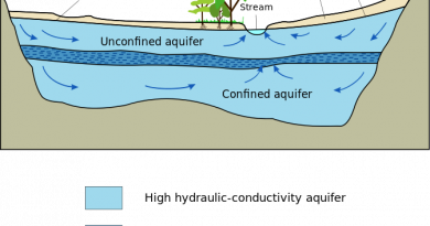
Unlike sub-soils, such as head and alluvium, most peat bogs can be accurately carbon dated – this is central to understanding post-glacial flooding as the flooded areas of Britain would be major contenders to accumulated marshes and bogs that would create the peat sub-soils of today (Fig. 37).
| Figure 37. – The growth of Peat reflects the flooded environment of the Holocene |
We can use peat not only to find the Holocene wet areas and raised river levels – but moreover, we can also use them to identify the size and flow of the rivers during the Mesolithic and Neolithic period.
Blanket bog occupies approximately 6 % of the area of the U.K. today. The Holocene expansion of this hyperoceanic biome has previously been explained as a consequence of Neolithic forest clearance. However, the present distribution of blanket bog in Great Britain can be predicted accurately with a simple model (PeatStash) based on summer temperature and moisture index thresholds, and the same model correctly predicts the highly disjunct distribution of blanket bog worldwide. This finding suggests that climate, rather than land-use history, controls blanket-bog distribution in the U.K. and everywhere else. (Gallego-Sala et al.,2016).
(a) regional graphs of initiation dates through time binned every 500 years;
(b) map of individual initiation dates; and
(c) map of initiation dates summarised per region.
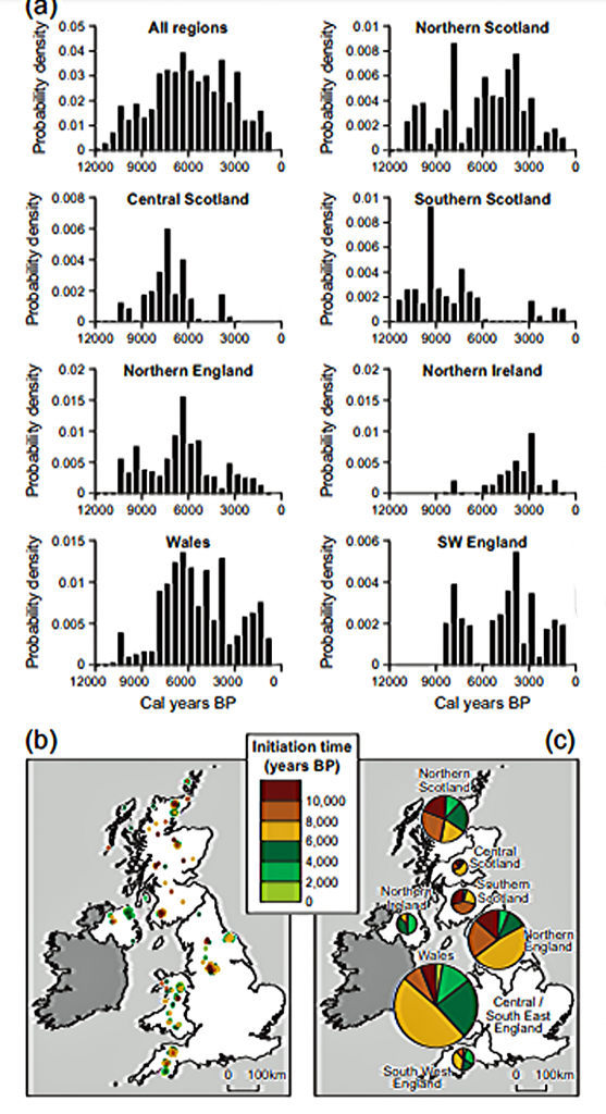
| Figure 38. Peats peaked some 4000 years after the LGM showing that Rivers were high and flowing until the Neolithic Period. ((Gallego-Sala et al.,2016). |
The maximum rate of peat production is not as one would expect directly after the meltwater flooding at the end of the Last Glacial Maximum, because if the waters subsided quickly, then its peak Peat rate would occurred in the early Holocene period. But what we see, is that the peak growth is 4000 to 6000 years later, as we see in Scotland (fig.28), the reason for this, is because the rivers were at their highest and fastest, early in the Holocene – not allowing the right environment for the growth of marshes and bogs. It is only when the rivers start to subside, that peats beginning to form, which is only interrupted, by occasional flooding, due to precipitation towards the end of the Neolithic period, and the onset of farming.
This growth of peatlands and their demise due to human activity is best seen from a case study of the upper Dee area in Scotland investigated and modelled by (Swinnen et al.,2019).
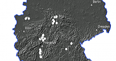
Case Study – Upper Dee
Blanket peatlands constitute a rare ecosystem on a global scale, but blanket peatland is the most critical peatland type on the British Isles. Most long-term peatland development models have focussed on peat bogs and high latitude regions. To calibrate the model, the peatland architecture was assessed along fifty-six hillslope transects in the headwaters of the river Dee (633 km2) in eastern Scotland, resulting in a dataset of 866 soil profile descriptions.
During the Holocene, large areas of blanket peatland have developed throughout the Scottish Highlands, and this shift from mineral to waterlogged and nutrient-poor organic soils is one of the most crucial Holocene landscape changes in Scotland. Different hypotheses have been raised regarding the cause of this peatland development (Tipping, 2008).
The original hypothesis, as proposed by Moore, linked the blanket peatland development in eastern Scotland to human impact, where anthropogenic land-use change and increased grazing during the Neolithic period led to a shift in the hillslope hydrology resulting in the paludification of the upland soils (Moore, 1973).
But what Moore has neglected is that Britain during the Holocene Period had a tiny population, which would eventually move to agriculture and farming much later in the Bronze and Iron ages – but not in the Mesolithic or Neolithic periods
The location map shows clearly the river system and sample area for the case study.
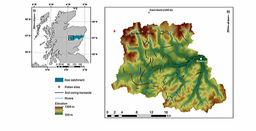
| Figure 39. Location of the Upper Dee area, with an indication of the slope transects and the pollen sites used. (Swinnen et al.,2019). |
With the river system that would periodically flood (as previously shown) then the thickness of peat and frequency can be easily identified, with earlier peat growth shown as deeper samples by the side banks of rivers and small lesser samples from the centre of the Holocene rivers, once the groundwater levels had shrunk leaving minor rivers as a consequence in more recent years.
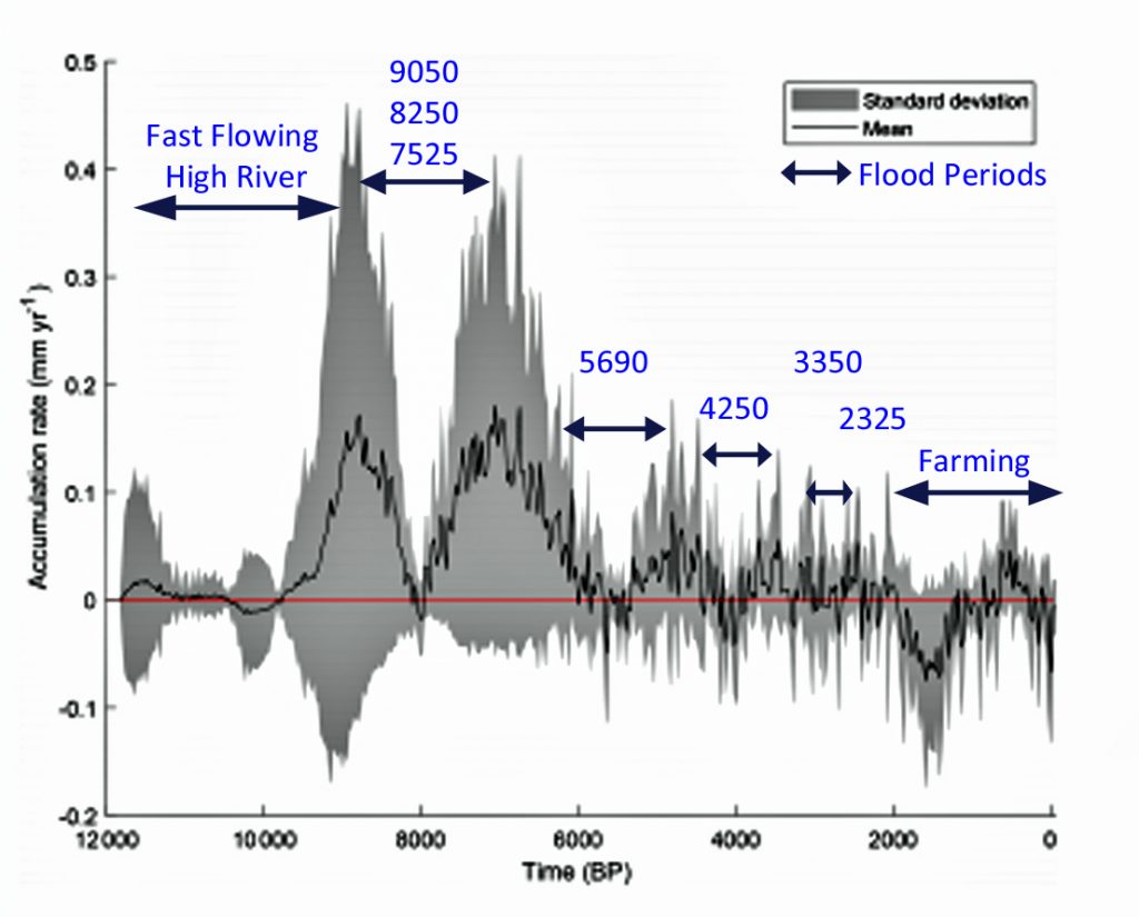
| Figure 40. – Peat growth Rates over last 10K years (Swinnen et al.,2019). Plus, added dates from (Macklin et al.,2006) |
This case study identifies that rivers were flowing after the last Ice Age (LGM) in existing rivers for at least 3 – 5k years before shrinking enough to leave marshes and wetlands that grew the plant life that would eventually become peat – interrupted only by spells of 500 – 100 years of re-flooding when the rivers regained past volumes and heights, as the weather changed.
and documentaries. The TRILOGY of books that ‘changed history’ can be found with chapter extracts at DAWN OF THE LOST CIVILISATION, THE STONEHENGE ENIGMA and THE POST-GLACIAL FLOODING HYPOTHESIS. Other associated books are also available such as 13 THINGS THAT DON’T MAKE SENSE IN HISTORY and other ‘short’ budget priced books can be found on our AUTHOR SITE. For active discussion on the findings of the TRILOGY and recent LiDAR investigations that is published on our WEBSITE you can join our FACEBOOK GROUP.