
Chapter 9 – Holocene Rivers in Britain
Book Extract……………………………..
A recent review of radiocarbon-dated Holocene fluvial deposits in the U.K., suggests that the lowland river systems in both the south and east of England experienced up to twenty flooding episodes between 11,190 and 390 cal B.P. (Johnstone et al. 2006, table 8).
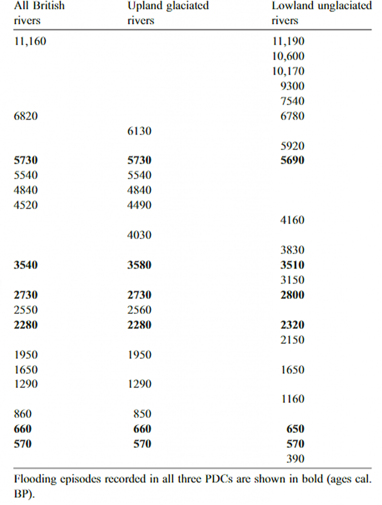
| Table 8 – Dates of River Flooding (Johnstone et al.,2006) |
Six of these episodes have been correlated to changing environmental conditions and in particular to large-scale variations in climate (Johnstone et al. 2006). The authors note that one explanation for the variable fluvial behaviour is the impact of anthropogenic land-use change in the mid-late Holocene (c. 4250 – c. 2050 cal B.P.) which would have increased the available runoff and sediment supply, making the river basin sedimentation considerably more responsive to changes in climate (Macklin and Lewin 2003; Johnstone et al. 2006)
These flooding events were immediately preceded by major agricultural innovations in Britain with the adoption of iron implements that could have increased runoff and erosion, resulting in enhanced flood-related sedimentation (Macklin et al. 2005).
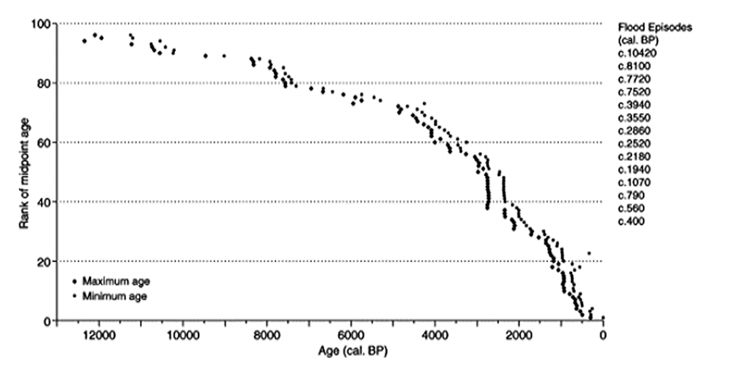
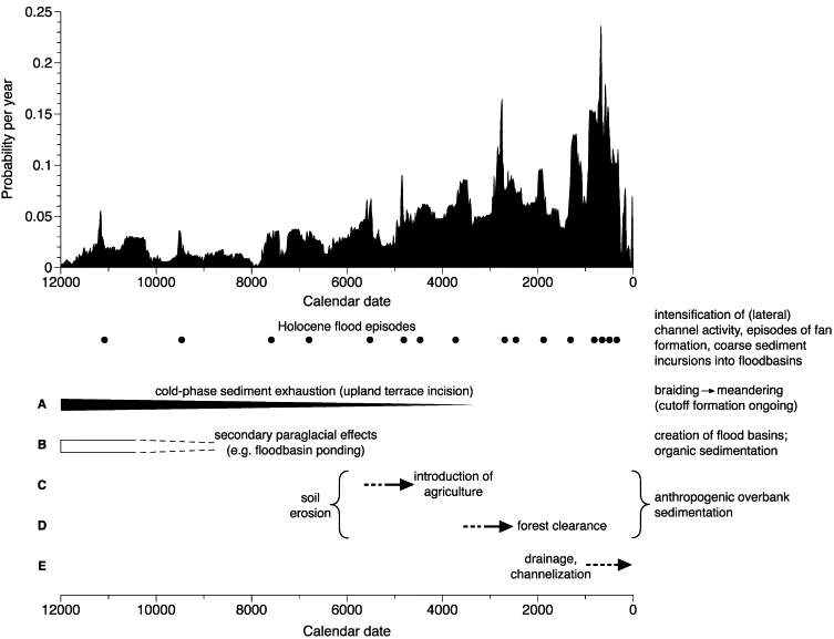
| Figure 45. – Flood episodes over the last 12,000 years since LGM. |
Alluvial sediments represent the principal source of information concerning patterns of Holocene fluvial behaviour and provide critical data for investigating cause and effect relationships between changing environmental conditions and river system activity (Baker et al., 1983, Starkel, 1983, Ely et al., 1993, Knox, 2000, Benito, 2003, Macklin and Lewin, 2003).
Macklin and Lewin (2003) identified 14 flood episodes in Britain during the Holocene (Fig. 32). They were able to pick out more detailed trends in regional patterns of flooding and variations associated with the four types of depositional environment. The 14 episodes of flooding were also compared to proxy climate records from Britain(Hughes et al., 2000), central Europe (Haas et al., 1998) and the North Atlantic (Bond et al., 2001) to evaluate the role played by climate change in influencing patterns of British river activity.
Despite the significant developments and improvements that have been undertaken in the last 15 years, some restrictions associated with the analysis of the 14C database remain. Many of these mirror data gaps and shortcomings exist in Holocene fluvial research as a whole. Problems include the inherent limitations associated with the temporal resolution of 14C dating techniques (Brown, 2003, Macklin and Lewin, 2003, Maddy et al., 2003) and of fluvial unit preservation (Lewin and Macklin, 2003), which mean that sedimentary archives of Holocene alluviation are incomplete and, indeed, may have ‘more gap than record’ (Lewin, 2001).
As a result to this last point, Macklin and Lewin (1993) also indicated that analysis of the database of 14C dates only highlights depositional episodes in the Holocene fluvial record, and does not identify phases of increased lateral channel movement, floodplain incision or erosion. Each of these may relate to flood events which are not recorded by sediment deposition at particular sites.
Terrestrial palaeoclimate indicators provide further evidence to suggest that large-scale changes in climate were the principal forcing mechanism for the nationwide flooding episodes. Periods of higher groundwater levels (and by inference wetter hydroclimatic conditions) have been identified, for example, from the mean lifespan of bog oaks in Germany, the Netherlands and Ireland, which correspond closely to British flooding episodes at c. 5730, c. 3540, c. 2730 and c. 2280 cal. B.P., though the bog oak record does not extend far enough for comparisons to be made with the c. 660, and c. 570 cal. B.P. flood periods (Leuschner et al., 2002).
Wet shifts recorded in mires across north-western Europe also provide evidence for widespread phases of climatic deterioration that correspond well with all but the earliest of the British flood phases (Hughes et al., 2000). For example, c. 2280 cal. B.P. phase of increased flood activity coincides with mire wet shifts reported in northern England (Barber et al., 1994, Hughes et al., 2000), southern Scotland (Chambers et al., 1997), Denmark (Aaby, 1976) and Norway (Nilssen and Vorren, 1991).
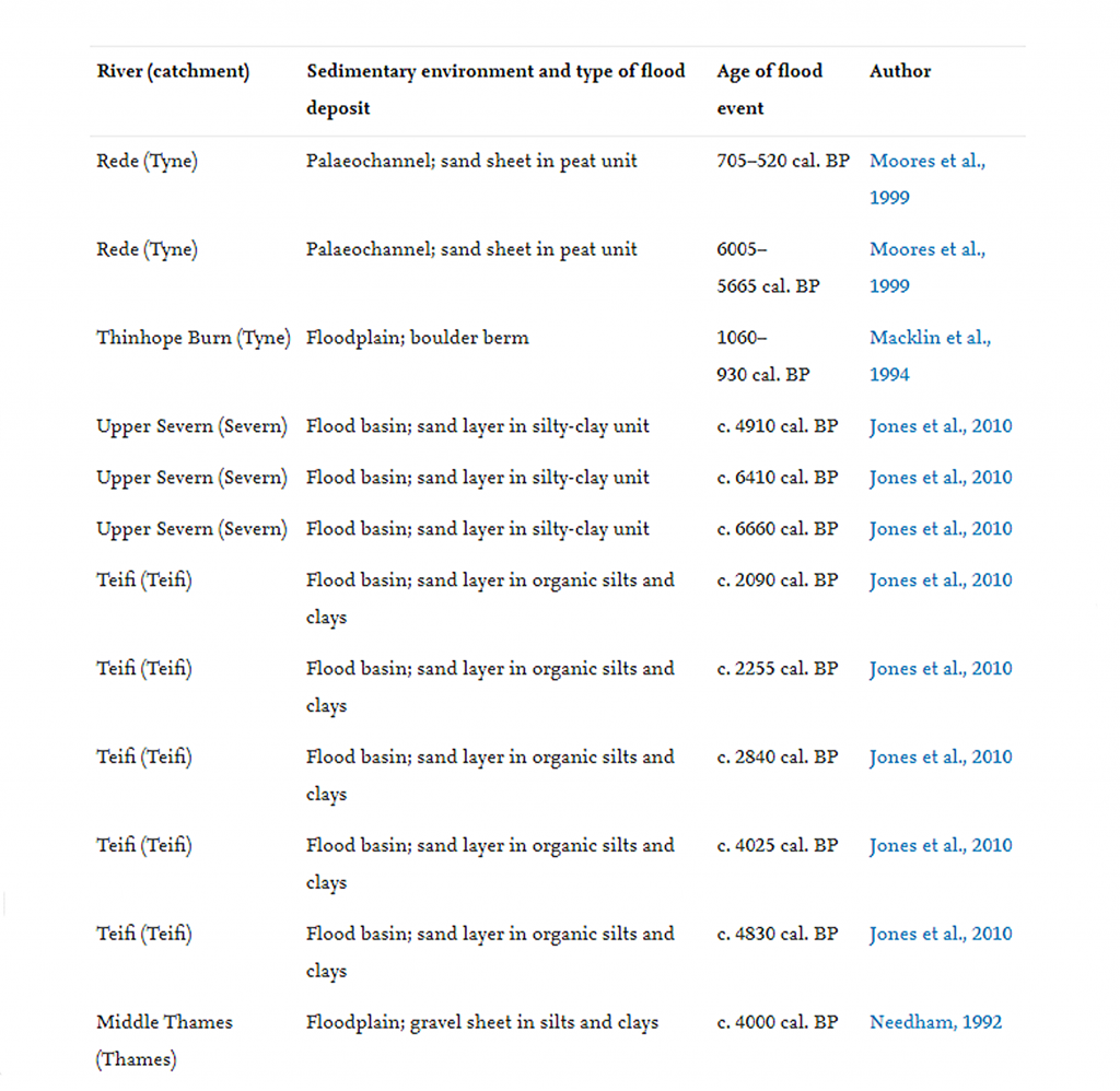
A total of 92 14C-dated fluvial units that relate to or bracket Holocene river incision episodes were recognised. These comprise a surprisingly small (c. 12%) sub-sample of the Holocene fluvial database. Over 60% of these 14C dates came from palaeochannels fills, 28% from floodplain sediments, just under 10% from lateral accretion deposits and only 1% from flood basins.
Dating phases of river entrenchment are best achieved using dates from active channel accretion deposits immediately above-cut surfaces, as these most closely reflect incision at a particular level. Dated floodplain deposits from adjoining terraces, generally permit comparison of overbank levels, while 14C ages from palaeochannels on neighbouring terraces, often involve episodic filling after terraces have been abandoned. In terms of evidence available, Holocene river incision phases in Britain are most constrained by 14C ages from palaeochannel fills. But to bracket incision timing most precisely, dates are required from floodplain surface sediments (end-stage aggradation) for the upper terrace level and the base of active channel accretion deposits (cutting stage) for the lower terrace.
At present, there is no site in Britain where Holocene river entrenchment is dated in this manner. Differences between incision levels may reasonably be assessed from terrace surface heights, but these may also reflect variations in the thickness of overbank sediments and time spans over which their deposition occurred.
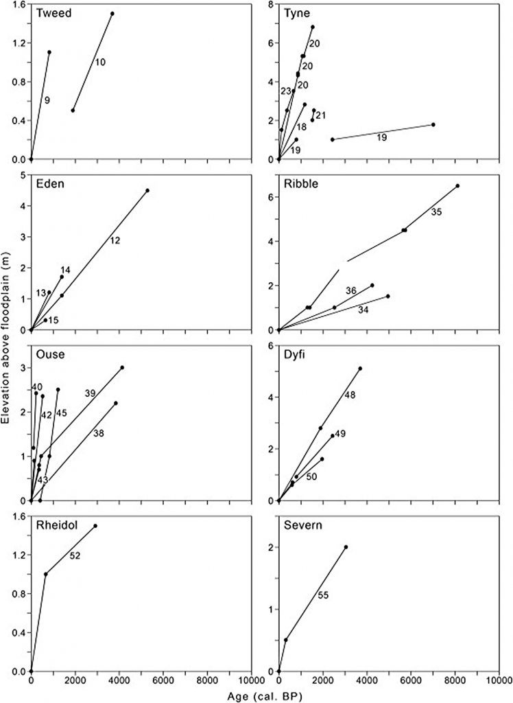
The change in elevation between successive and dated river terraces is graphed for selected catchments in northern England, Wales and Scotland (Fig. 46) where the height and age of consecutive terraces are well constrained.
The suggested interplay between ‘resetting’ and ‘normal’ river erosion and sedimentation had two critical effects. After resetting, flood flows were contained within a more confined valley floor (Fig. 47, b1), allowing the flood and channel scour depths to be higher for a given extreme hydrological event. Lateral erosion was also constrained by increased bank height (b2), and this affected the volume of sediment to be removed during lateral migration and valley-floor expansion. In effect, floodplain widening became more complicated and entrenchment easier. These tendencies were repeated and enhanced in subsequent periods (C).
Thus the impact of extreme hydrological events was mediated by the morphological consequences, timing, and inter-event activity from previous incision episodes. Such feedback effects may at least in part explain both the progressive valley-floor narrowing and higher vertical incision rates in the latest Holocene. However, there is also the likelihood that an increased incidence of massive floods arising from anthropogenic effects may have sensitised the system to produce more rapid runoff (cf. Macklin, 1999, Coulthard and Macklin, 2001, Lewin, 2013).

| Figure 47. – Model of Holocene River Entrenchments |
This systematic review of Holocene river entrenchment in Britain shows that entrenchment events/episodes were responsible for periodically re-setting river channel and floodplain dynamics. Incision periods correlate with regional peatland water-table records indicating that climatically related changes in flooding frequency and magnitude were the primary controls of river entrenchment.
The collated evidence indicates that river entrenchment is highly episodic, relatively short-lived and relates to the most extreme hydrological events of Britain’s Holocene, which re-set alluvial systems in northern and western Britain to lower topographic levels. Here entrenchment episodes deepen channels with subsequent lateral channel movement and sedimentation widening valley floors. In this context, extensive terrace treads equate to periods of extended lateral reworking without entrenchment events re-setting the channel system to a lower level.
It should be noticed that these flood episodes became more frequent as time went by and not at the start of the Holocene period where it would have been expected to happen with a higher water table and occasional meltwater pulses. But fast discharging higher water levels would leave very little ‘evidence’ of silt and sand on the edges of rivers or the growth of reeds and other plant life, as it was only once the rivers reduced in size and discharge could such evidence been able to form.
The only logical conclusion is that the river volume and discharge in the early Holocene period were much higher than in latter flood periods during the Neolithic to the Iron Age period and that additional precipitation was the cause of these flooding episodes as illustrated in Fig.14.
Therefore, looking at Fig. 48. We can see that the growth of floods began 8,000 BCE and reached a peak less than a thousand years ago, when soil erosion and farming techniques evolved.
For more information about British Prehistory and other articles/books, go to our BLOG WEBSITE for daily updates or our VIDEO CHANNEL for interactive media and documentaries. The TRILOGY of books that ‘changed history’ can be found with chapter extracts at DAWN OF THE LOST CIVILISATION, THE STONEHENGE ENIGMA and THE POST-GLACIAL FLOODING HYPOTHESIS. Other associated books are also available such as 13 THINGS THAT DON’T MAKE SENSE IN HISTORY and other ‘short’ budget priced books can be found on our AUTHOR SITE. For active discussion on the findings of the TRILOGY and recent LiDAR investigations that is published on our WEBSITE you can join our FACEBOOK GROUP.