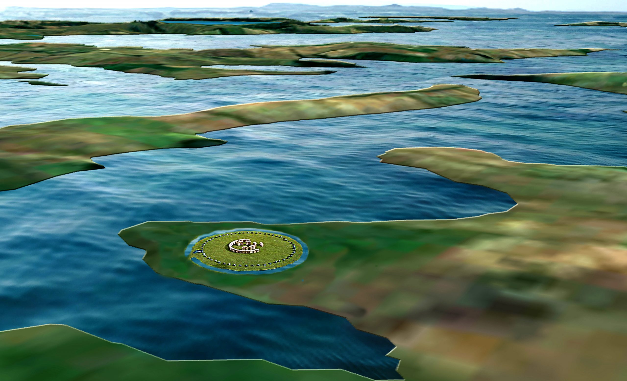
Chapter 7 – Britain’s Post-Glacial Flooding
Book Extract……………………………..
When floods rise and fall, they characteristically leave behind a sediment signature. This is generally heterolithic in character; they incorporate sequences or couplets both of coarser material from peak discharges and finer material from waning flows or even inter-flood discharges (Macklin et al.,1992).
In channel zones, flood mobilisation of coarse materials may lead to both channel erosion, and deposition producing mesoscale bed and bar forms (Fig. 23), which have a distinct topographic expression (unit bars of languid form, scour pools, and flood berms and scrolls at channel margins, for example). These may be extended by growth at their margins during succeeding and lesser discharges.
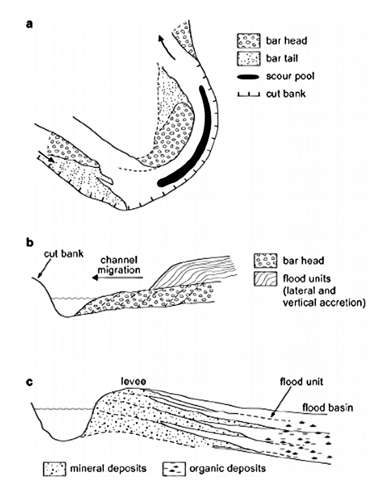
| Figure 23. Flood segment units, showing (a) in-channel bedforms. (b) Channel margin accretion and (c) Floodplain depositional sites (Macklin et al., 1992) |
Moreover, where sediment sheets are deposited at channel margins at various flood stages, the generally finer suspended-sediment units may exhibit textural changes, usually in the form of smaller-scale coarse fine grading marking the transition from flood peak to the waning stage. Unit thickness may relate to not only flood duration and magnitude, but also sediment loadings and to flood sequence sediment-exhaustion.
Dated materials come from a variety of contexts in relation to alluvial units (Fig. 24). They may relate to the termination (a) or onset (b)/(c) of unit formation or mark a change in sedimentation (e.g. in texture) within a unit (d).
Whilst it appears from the literature that researchers have in practice tended to attempt dating at hiatuses of one kind or another, many dates nonetheless ‘float’ within sedimentary bodies which were actively accumulating over long periods of time (e in Fig.24.). It is interesting to note that in the present Holocene fluvial archive, the proportion of dates recording changes in sedimentation style increases from form units A to D.
a) giving minimum age (may include situ growth)
b) giving maximum age
c) at base within the unit (incl. in situ growth and floated and re-eroded timbers)
d) making changes within the unit
e) within unit giving ‘floating’ date
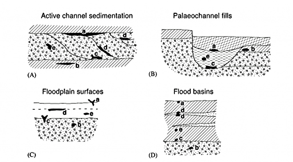
| Figure 24. Alluvial Dating Units (Macklin et al, 1992) |
Thus, flood basin ‘events’ appear to be relatively well pinpointed, but only a third of lateral accretion deposits convey information other than that channel migration was active at the time—but probably for much longer. However, relatively few form units have multiple dates to allow periods or rates of activity to be precisely determined.
For the recording of out-of-channel extreme events and finer sediment deposition, this is not the case. The relative absence of sandy sediments in many U.K. rivers is also something of a disadvantage because most overbank deposited materials are derived from eroded soils, and these get widely deposited from turbid waters whatever the magnitude of flood involved. Some geological materials in Britain yield a diagnostic range of sediment sizes (e.g. catchments underlain by mixed Carboniferous rock types – Macklin et al., 1992b). Still, unfortunately for flood-power recording, many do not.
It should also be borne in mind that flooding is not the only way in which heterolithic sediments are formed; thus, Thomas et al. (1987) list many types of inclined heterolithic sedimentation. Migrating in-channel sand and gravel sheets, for example, may leave their signature and some care has to be exercised in distinguishing autogenic (derived from a variety of continuing rhythmic sedimentation processes) and allogenic signals (marking externally generated hydrological events) for purposes of building up a flood event history.
Palaeochannel River channels (dry river valleys) may become abandoned by avulsion and cut-off processes in a variety of channel patterns; channel sediments may accumulate to ‘seal’ either or both ends of the abandoned reach which subsequently may be infilled over an extended time period by flood deposits and organic accumulation. Such processes have been assessed in some detail for contemporary meandering rivers (see, for example, Johnson and Paynter, 1967; Lewis and Lewin, 1983; Hooke, 1995), but also for braided (Leddy et al., 1993) and anastomosing systems (Smith et al., 1989) together with avulsions involving extended-reach abandonment (Jones and Harper, 1998).
Abandoned Palaeochannels may constitute around 15% of the active sedimentation surface in braided rivers (Bristow, 1987) and 10% in meandering ones (Lewis and Lewin, 1983). Relict channels are often found defining outer terrace margins (Lewin and Macklin, 2003) where they may be readily sampled for purposes of dating and environmental reconstruction.
Additional complexity is provided by systems changes in which more extensive channel networks (as in braided rivers) are replaced by a less extensive one (as in a single thread meandering channel). This, for example, has been suggested for the early Holocene in lowland Britain, where the infilling of redundant channel branches over a timespan of millennia has been proposed (Brown et al., 1994). In such situations, channel fills may considerably post-date the formation of the channels they occupy. The actual record of sites directly showing phased channel contraction is, however, rather sparse.
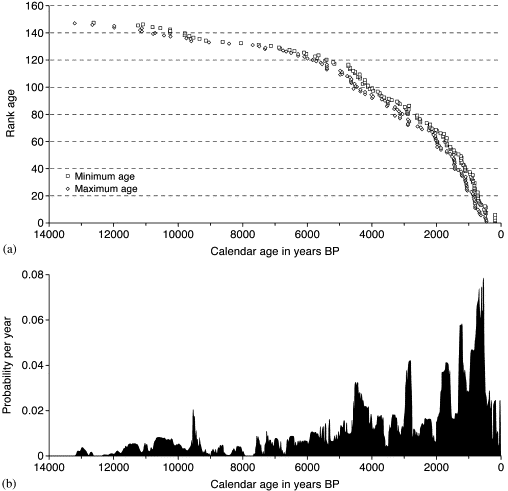
| Figure 25. One Hundred and Forty-seven Recorded Flood frequencies in Britain during the Holocene (Lewin and Macklin, 2003) |
This indicates that a majority of Palaeochannel units (147 in the Lewin and Macklin, 2003 study) were active during the Holocene due to the rise in the water table up to just 1000 years ago. Moreover, as pointed out within the paper “Constant Holocene sedimentation might be expected to produce straight-line cumulative plots and even probability levels, with deviations representing episodic or increasing/decreasing trends inactivity.
However, the uneven preservation of alluvial units (Lewin and Macklin, 2003) biases the ‘recorded’ alluvial archive in different ways, especially but not exclusively towards later Holocene sediments. Furthermore, 14C dated materials are also likely to appear bunched in relation to 14C production variability, which may or may not coincide with flood production, so that to an extent the spikiness of the illustrated plots represents more complex factors than episodic alluviation alone. These factors need to be borne in mind when interpreting the data presented.”

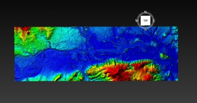
Figure 26. Lidar data mapping of a typical river system over time
For more information about British Prehistory and other articles/books, go to our BLOG WEBSITE for daily updates or our VIDEO CHANNEL for interactive media and documentaries. The TRILOGY of books that ‘changed history’ can be found with chapter extracts at DAWN OF THE LOST CIVILISATION, THE STONEHENGE ENIGMA and THE POST-GLACIAL FLOODING HYPOTHESIS. Other associated books are also available such as 13 THINGS THAT DON’T MAKE SENSE IN HISTORY and other ‘short’ budget priced books can be found on our AUTHOR SITE. For active discussion on the findings of the TRILOGY and recent LiDAR investigations that is published on our WEBSITE you can join our FACEBOOK GROUP.